Further Road Bike Tours

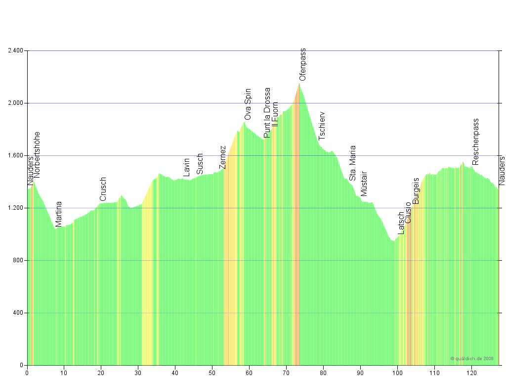
Round trip to the Ofenpass 128.8 km – 2,404 m Elevation

Norbertshöhe - Scuol - Zernez - Ofenpass - Sta Maria - Latsch - Reschen - Reschenpass - Nauders


This beautiful round trip bike tour leads through the Unterengadiner Dolomites and the Swiss national park to the Ofenpass, which offers views of the majestic Ortler mountain peak on good weather days. The tour continues at a faster pace downhill to the Münstertal valley in the Vinschgau valley and back along the narrow Vinschgau bike path with no motor vehicles to your starting-off point in Nauders.


Elevation:

Ofenpassrunde Höhenprofil

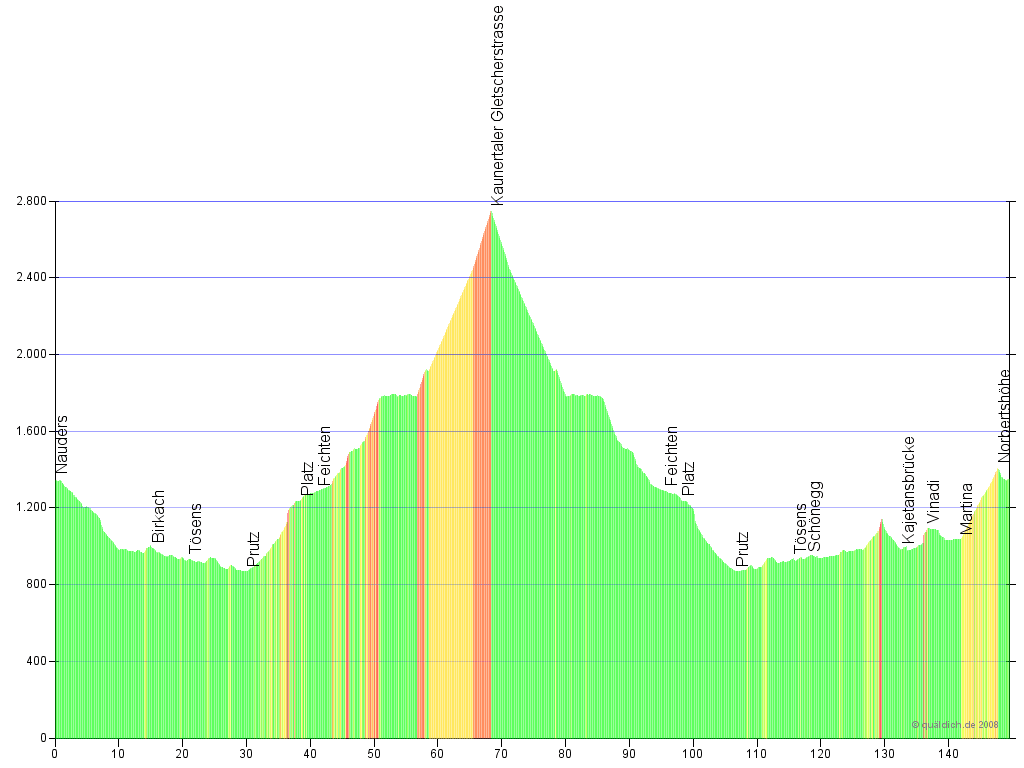
Kaunertal Glacier Road 149.5 km – 3,212 m Elevation

Kajetans bridge - Prutz - Kaunertaler glacier road - Martina - Norbertshöhe - Nauders


Challenging tour to the Weißseeferner mountain at the end of the impressively constructed Kaunertal glacier road. The tour takes bikers down the Reschenpass road to the Kajetans bridge and then towards Prutz on minor roads to the start of the glacier road. On the way back to Nauders the tour leads along a less-frequented road to the Norbertshöhe.


Elevation:

Kaunertalrunde Höhenprofil

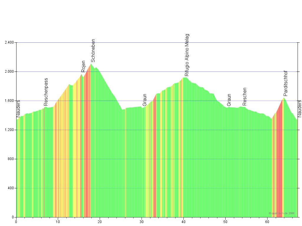
Schöneben and Langtauferer Valley 67.2 km – 1,769 m Elevation

Reschenpass - Reschen - Rojen - Schöneben - Graun - Langtauferer Tal - Graun - Reschen - Nauders


This circular tour takes bikers around the Reschensee with stunning views of the legendary church tower in the lake. The route leads along the hills to the left and right of the lake, to Rojen and Schöneben with many historic and culturally important chapels along the way. Both towns are situated at about 2,000 m above sea-level. At the end of the Langtauferer valley bikers are rewarded with magnificent views of the pristine alpine landscape up to the glacier of the Weißkugel massive.


Elevation:

Reschenseerunde Höhenprofil

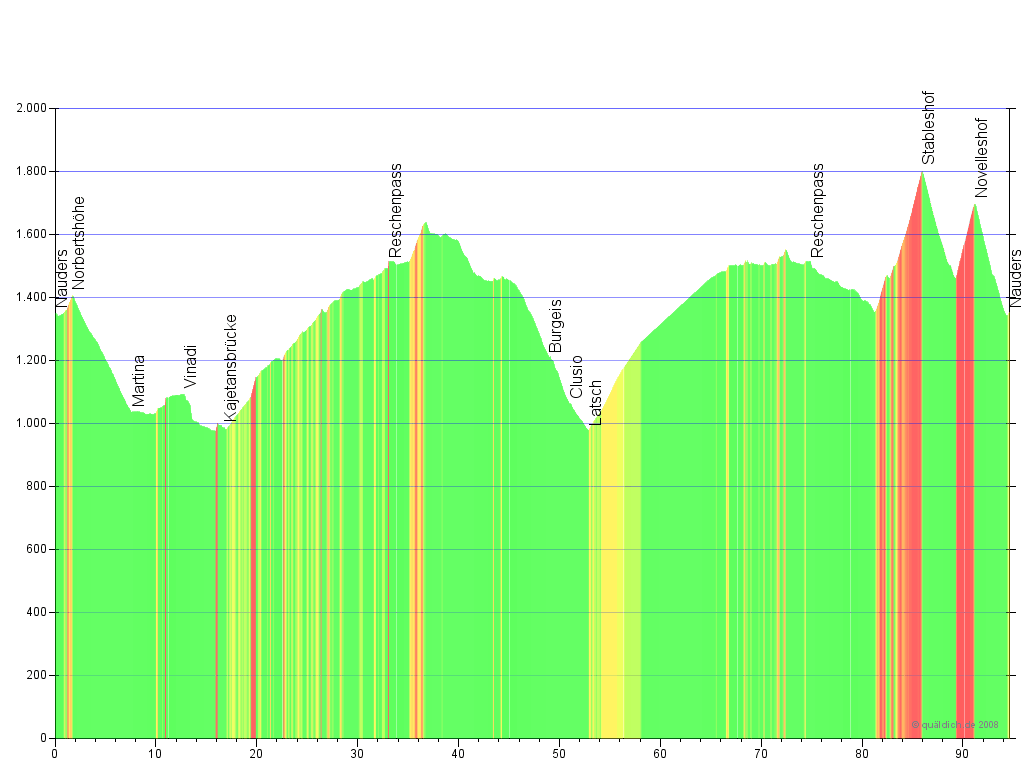
Double Reschenpass 96.1 km – 2,383 m Elevation

Norbertshöhe - Martina - Kajetans bridge - Reschenpass - Burgeis - Latsch - Stableshof - Novelleshof - Nauders


The double Reschenpass: One climb from the north and one from the south. Taking full advantage of early sunrays and less traffic, the tour starts off climbing the Reschenpass from the north. The tour leads past the Reschensee lake along the alpine track past Spinn and then past the Haider alpine lake on a bike path to the west. From there, the tour leads back to the Reschenpass road towards St. Valentin, crosses over to the western bank of the Reschensee and continues back to Nauders on the hilly lakeside bike path.


Elevation:

Doppelter Reschenpass Höhenprofil

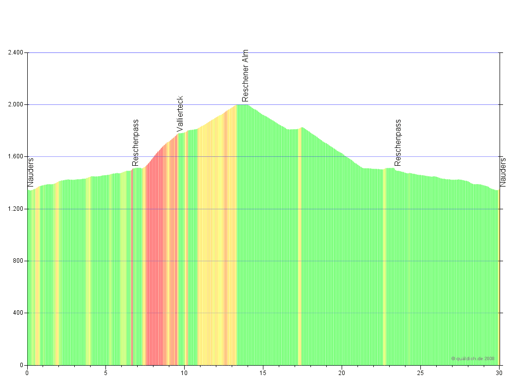
Adventure Tour to Vallierteck 30 km – 746 m Elevation

Reschen - Vallierteck - Reschener Alm - Reschen - Nauders


This tour is a more relaxed bike ride on an adventurous path to the Vallierteck. This church is situated above the Reschen, at the hillside of the Reschen Alm alpine hut, and is easily accessible along a steep tarmac road. There is a short 200m distance that requires bikers to carry their bike due to a gravel road. After that, the biking continues on a lovely road, which is easily rideable by roadbike, to the Reschener Alm alpine hut with fantastic views of the Reschensee lake. 


Elevation:

Vallierteck Höhenprofil

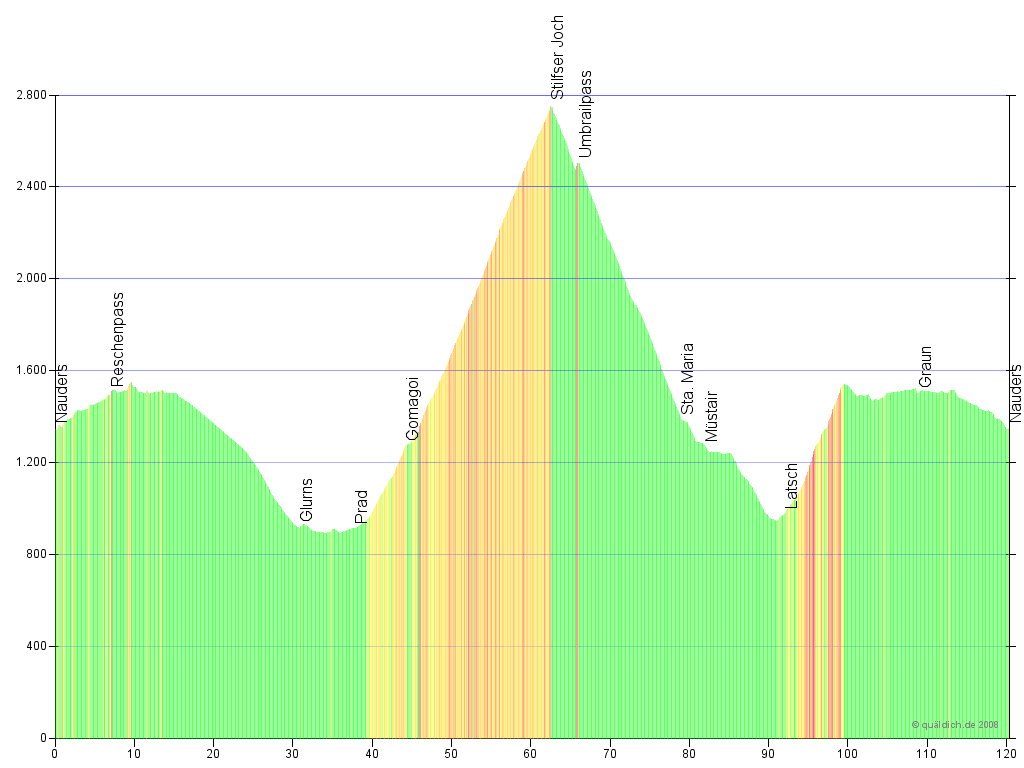
Tour to the Stilfser Joch 120.3 km – 3,075 m Elevation

Reschen - Glurns - Prad - Stilfser Joch - Sta Maria - Latsch - Ulten - Reschen - Nauders


This crowning stage leads up to alpine road royalty. The Stilfser Joch challenges bikers with 48 hairpin turns, more than 1,800 metres in elevation, and is on the bucket list of all mountain pass road bikers.

The return trip takes bikers along the Umbrailpass into the Münstertal valley and then continues into the Vinschgau valley. The Reschenpass is circumvented by passing Ulten and then challenges bikers with the steepest section of the tour at 15% for 300 m.


Elevation:

Stilfser Joch Höhenprofil

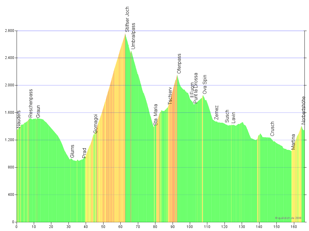
Big 3-Country Giro Round Trip 166.1 km – 3,762 m Elevation

Reschen - Glurns - Prad - Stilfser Joch - Sta Maria - Ofenpass - Zernez - Martina - Norbertshöhe - Nauders


All bikers looking for the ultimate challenge can embark on the tour to the Stilfser Joch and then continue to the Ofenpass and the Unterengadin down to Martina. From there the final climb to the Norbertshöhe will challenge bikers at the final section of this tour.


This alternative additional route is an extremely challenging tour and the big tour of the Dreiländergiro (transl. 3-Country Giro).


Elevation:

Dreilandergiro Runde Höhenprofil

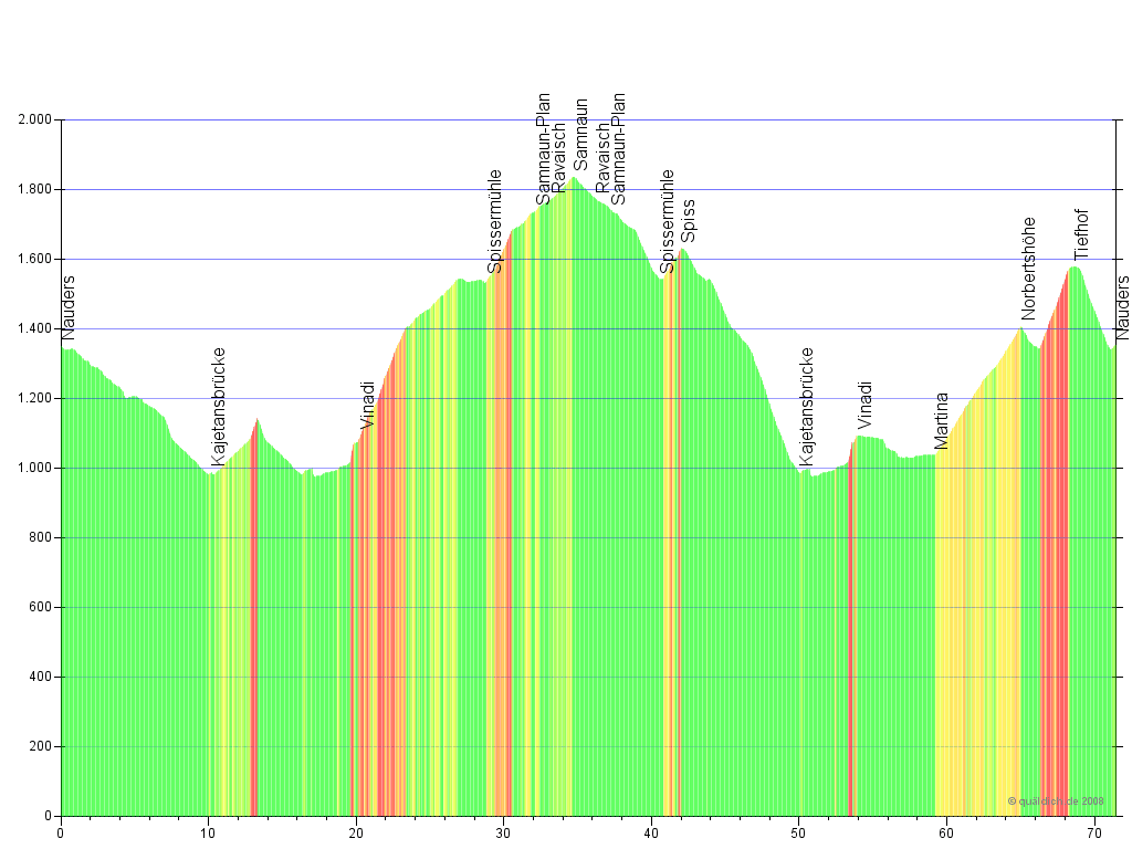
Customs-Free Zone in Samnaun 71.5 km – 2,017 m Elevation

Kajetansbrücke - Vinadi - Samnaun - Kajetansbrücke - Vinadi - Martina - Norbertshöhe - Nauders


The tour starts down the Reschenpass road to the Kajetans bridge and from there, turning left, heads into Switzerland. In Vinadia a fantastic road carved out the bedrock of the mountain leads up to the customs-free zone Samnaun. As you head back, the new Austrian road takes you to the Kajetans bridge. Instead of heading up the Reschenpass from there, the tour continues to Martina and up to the Norbertshöhe on a 11-hairpin-turn climb back to Nauders.


Elevation:

Samnauntour Höhenprofil

You must allow cookies of the following categories to view this content: Features Change cookie settings

All Experiences


logo bikeholidays

logo roadbike

logo tripadvisor

logo holidaycheck

We use cookies
To ensure this website is correctly displayed, we use the help of cookies. Some are required for website functionality, while others allow us to collect anonymous user statistics. For more detailed information, please read our privacy policy.
I allow cookies for the following purposes:
Save